By: FARAZ AHMED CHANDIO
David Jiménez described in his book the Monsoon Children, 2008, that we in the South Asia are the Children of Monsoons.
While Government may not acknowledge it, we are connected by an ecosystem wherein our resilience are intertwined by the climate of the whole south asia.
Common Ecosystems
- Rivers: The Indus River system is the main lifeline of both India and Pakistan and has Six Major tributaries, namely, Eastern: (Beas, Ravi, Sutlej) and Western (Indus, Jhelum, Chenab).
These shared waters are more than 90 % of Pakistan. It is agriculturally utilized by and sustains 7 Indian States and Union Territories (UTs) namely, Punjab, Haryana, Chandigarh, Indian occupied Jammu & Kashmir, Rajasthan, Himachal Pradesh and Delhi. Monsoons and negligence of cross border control are the main causes of fatal floods in the Punjab and Sindh.
- Mountains: The Hindu Kush, Karakoram and Himalayan ranges are of the same geo-liquid structure. The Himalayan watershed runs across the northern part of India in the occupied J&K, Himachal Pradesh, Uttarakhand, Sikkim, Arunachal Pradesh and extends towards the west in Pakistan.
The Karakoram is mostly in Gilgit-Baltistan and extends in the disputed Ladakh and Aksai Chin. Hindukush is located in Afghanistan in the North Western Pakistan and it joins with Karakoram at the eastern end.
In northern Pakistan, where the Gilgit and Indus rivers meet, there are three mountain ranges which converge. This complex system contains some of the most cavernous and deepest glaciers that are significant contributors to Glof volcanism, spattering a geologically caucasian landscape.
Downstream calamities are integrally preventable Glof volcanism.
- Deserts: The Thar desert extends over the expanse of India and Pakistan, boosting the rate of desertification and drought in either subcontinents.
This sizeable arid subtropical desert is characterized by low, erratic rainfall, and rough in a case of soil erosion and water scarcity, thereby raising the urgency for inter-basin water transfers of the order of the Beas–Bikaner and Indira Gandhi canals. The most expansive and critical section of the desert is located in India, specifically Rajasthan, Gujarat, Punjab and Haryana, with the rest extending into Pakistan’s drought-prone districts in Sindh (Pakistani Punjab) and Punjab (the Cholistan desert).
- Coasts: This maritime climate zone impacts monsoon weather, tropical cyclones, and the ocean’s currents, which in turn affects the coasts of India and Pakistan.
Powerful tropical cyclones of the Arabian Sea pose a transboundary threat for Pakistan, coming close to the 2,500 km of India’s western coastline.
The last few years have witnessed a rise in the intensity and frequency of storms, amplifying the risks.
5) Delta: The broad Extent of the Indus delta mangroves is also divided. These mangroves rely on the Arabian Sea – originated tidal waters and the Indus’ flows of freshwater that balance the salt, sediment and nutrients needed for the growth.
From Thatta, Badin, Sajawal and Karachi to India’s Gujarat coast, The Rann of Kutch also straddles the border with the larger portion in Gujarat and a smaller in Sindh. It is a seasonal flooding basin in the monsoons, transforming from a desert to marsh – like a desert mirage.
6) Interconnectedness: Climate disasters have a chain reaction. From one place to another to the other, triggering downstream floods in the other places. Upstream and downstream dynamics is crucial to identifying disaster chains in climate – triggered disasters.
Most of the climate triggered events, especially the disturbing flows within the Indian states or held territory, cascade downstream to Pakistan. The upstream-downstream dynamics explain the disaster chains that are cited in the following three case studies, especially, the Kashmir floods.
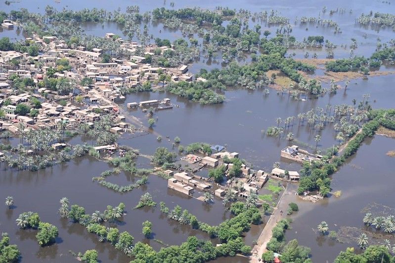
a) Kashmir floods: In September 2014 heavy post monsoon rains triggered unprecedent floods in the Kashmir region and the downstream areas on both sides were devastated.The Jhelum and Chenab in Kashmir severely flood on and before many developing countries, and the Chenab and the Jhelum are the two main rivers that overflow and flood the Kashmir region. This flood caused the Chenab and Jhelum rivers to flood many of its surrounding areas, specifically in Srinagar and many of its surrounding villages. The flood took its natural course down toward Punjab, Pakistan, where it impacted over 1.1 million and completely flooded over 700 cities. The floodwaters caused river banks to break, which led to further causing displacement and which caused the whole region to flood. This flood showed how vulnerable Pakistan is to extreme climate conditions, and this flood showed how climate conditions are a threat to the country and caused a high determination for countries to share warning systems for the climate.
The spring 2022 heatwave and climate conditions are located in Pakistan and in Northern united India. During this period, it reached over 49 degrees Centigrade in many areas of the region, which is a record high for this period. The heatwave caused extreme climate conditions in India and it also caused global wheat prices to go up as it caused the wheat crop to fail, which lowered the food available in the world. The heatwave also caused and triggered the melting of snow in glaciers and it caused extreme climate conditions across the whole country. This event shows how extreme climate conditions in India and in Pakistan can severely impact the climate in other countries.
c) Arabian Sea Cyclones: Tropical cyclones in the Arabian Sea develop in close proximity to India’s longer coastline and then impact Pakistan \textit{in line with the movement of the weather systems}. Tropical cyclones \textit{Kyarr} in 2019 did not impact land but caused coastal flooding and tidal surges in Maharashtra and Gujarat and then went on to affect Sindh and Balochistan.
\textit{Tauktae} 2021 is one of the deadliest cyclones in the Arabian Sea. \textit{Tauktae} had extreme destructive rains and high ferocious winds which resulted in shut downs of densely populated areas in the west coast of India and forced a massive evacuation due to the infrastructure disruptions it caused. These demonstrations show the significant climate threats in the world today and how such threats reduce down stream.
Global Lessons: Despite having no diplomatic relations since 1993, \textit{Armenia} and \textit{Türkiye} show that hostile political environments cannot constitute a prohibition on shared dam management. They operate the \textit{Arpaçay Dam} under hostile political environments, managing it through monthly meetings that share water equitably according to agreements of 1927.
In contrast is \textit{Ethiopia’s} unilateral construction of the \textit{Grand Ethiopian Renaissance Dam}. It did not receive the consent of the downstream countries which are in this case \text{Egypt} and \text{Sudan}. This construction is the cause of the permanent regional tension that illustrates the type of conflict that cooperative management is crucial in avoiding.
India and Pakistan need to address climate change, and these shared ecological conditions confirm that need to be immediate. Each case study details the Indian-originated disasters that flow downstream to Pakistan. This makes the need for collaborative early warning systems and shared water infrastructure management vital for Pakistan’s ability to adapt. Relatively lower control systems on flood gates upstream dam Pakistans’ control and flood management.
From the 2025 floods, the fundamental lesson is that only climate coordination can eliminate downstream disasters and suspicions of water terrorism. Flood control and dam infrastructure on the east side of the border would help provide emergency relief to both nations and foster climate collaborative trust. Disasters will not stop cascading, and neither nation can manage them alone, as is currently the case.